The Vertical Threshold of the Sierra Tarahumara
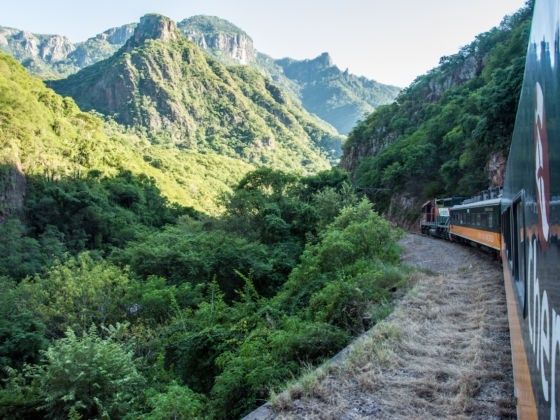
At Creel, the Sierra Tarahumara still presents itself in the language of altitude: pine forests, cold air, granite outcrops, and a horizon arranged in long, quiet ridges. Then the railway begins to move toward the Copper Canyon, and the landscape changes from a high plateau into a broken architecture of ravines. The track does not simply cross this country. It negotiates with it, descending through rock, doubling back on itself, and passing repeatedly from open forest into shadowed cuts and narrow valleys.
For passengers, the first impression can be romantic. The windows frame improbable views, the carriages offer a composed vantage point, and the journey is often approached as a scenic excursion. Yet the romance is only the surface of the experience. Beneath every panorama lies the mechanical scale of crossing the Sierra Madre Occidental, a project that required surveying, blasting, bridge building, drainage, maintenance, and an unusually patient response to terrain that resisted straight lines.
That tension gives El Chepe Express its deeper significance. The railway is a disciplined mid-century intervention in an ecosystem whose slopes, watercourses, forests, and settlements remain anything but rigid. Its steel alignment suggests control, while the canyon continually demonstrates the limits of control. To travel through the mountains is therefore to watch engineering and geography share the same narrow stage.
Conceiving the Line Across Impassable Gorges
The Chihuahua-Pacific railway emerged from a nineteenth-century ambition to connect the interior of northern Mexico with the Pacific coast. The vision took institutional form under Porfirio Díaz, and construction began in 1902, but the route was never a simple extension of an existing network. It had to cross the Sierra Madre Occidental, where deep canyons, unstable slopes, sharp changes in elevation, and difficult weather imposed obstacles that contemporary railway construction could not solve quickly.
Politics and finance proved nearly as difficult as the mountains. The project developed amid changing concessions, economic uncertainty, and the upheaval that preceded and followed the Mexican Revolution. Work advanced unevenly, and the line”s completion became a matter of decades rather than a single construction campaign. Thousands of laborers participated over time, with estimates reaching roughly 20,000 workers, while the eventual cost has been estimated at approximately 1,133 million pesos. The figures convey not only expense but duration, persistence, and the administrative challenge of maintaining a national project across remote territory.
The decisive Creel to San Pedro section was completed and inaugurated on November 23, 1961, during the presidency of Adolfo López Mateos. That date marked more than the opening of a railway segment. It completed a physical connection between regions that had often been imagined as separate, and it altered the national perception of northwest Mexico as a severed geography. The historical record of the railway and its place in the national network can be explored through this archival account of El Chepe, alongside this Authoritative Source on the railway”s broader national significance.
The Brutal Calculus of Tunnels and Spans
The route”s headline numbers remain startling because they describe a continuous argument with altitude. Across approximately 653 kilometres, the railway passes through 86 tunnels and over 37 major bridges. Each tunnel shortens a mountain that could not be crossed economically by open cutting, while each bridge carries the track across a void that would otherwise force a much longer descent or ascent. The line is consequently best understood not as a single engineered object, but as a sequence of local decisions made coherent by a larger route.
The Chinipas Bridge represents the drama of spanning canyon country, while the Temoris section demonstrates the ingenuity required when the gradient becomes the principal adversary. There, the railway uses a looped descent to lose elevation without resorting to an impossible direct plunge. The technical achievement is not merely visual. It is embodied in the train”s measured pace, the curvature of the alignment, and the repeated need to protect the track from water, rockfall, and seasonal change. For readers interested in the technical and architectural lineage of Mexican railways, the scholarship gathered in Mexican railway studies offers valuable wider context, complemented by this Authoritative Source.
| Route element | What the traveler observes | Primary technical challenge |
|---|---|---|
| High Sierra near Creel | Pine forest, open upland, cooler air | Maintaining a stable alignment across elevated terrain and seasonal weather |
| Tunnel corridors | Repeated transitions from daylight into rock-cut darkness | Excavation, ventilation, drainage, and long-term rock stability |
| Bridge sections | Sudden views across ravines and canyon walls | Spanning deep gaps while resisting wind, water, and shifting foundations |
| Temoris descent | Curving track and the sensation of a controlled vertical journey | Losing elevation gradually through loops, curves, and carefully managed gradients |
These structures also change the meaning of time aboard the train. A bridge compresses distance into a brief exposure, while a tunnel suspends the view entirely. A loop makes the passenger aware of direction, revealing the line”s own geometry as the train turns against the mountain. The journey becomes a lesson in infrastructure that can be read directly through motion.
Vertical Ecology and the Vanishing Scent of Pine
The descent from the high country around Creel, approximately 2,400 metres above sea level, toward Los Mochis and the Pacific lowlands is a passage through sharply differentiated ecological zones. At the beginning, conifers define the atmosphere. Pine resin, dry needles, cool shade, and thin mountain light establish a sensory vocabulary associated with elevation. The landscape appears spare in places, yet its forests and rocky clearings reveal the severity of the highland climate.
As the railway loses altitude, the air changes before the vegetation is fully understood. Dry upland textures give way to warmer scrub, denser growth, and riparian vegetation gathered around watercourses at the canyon bottoms. The same journey can move through cool, dry mountain conditions and into subtropical heat, with the canyon walls creating local climates that vary over relatively short distances. This is why the route feels less like a single landscape than a vertical catalogue of northern Mexico.
Inside the passenger cars, the ecological transition becomes intimate. Windows that initially admit crisp air and the scent of pine later open onto damp warmth, dust, and the heavier fragrance of vegetation near lower valleys. The changing atmosphere is easy to overlook when attention is fixed on dramatic viewpoints, but it is among the clearest evidence that the train is crossing altitude rather than merely passing scenery.
- High uplands: cool temperatures, conifer forest, exposed rock, and broad mountain light.
- Canyon slopes: warmer air, sharper shadows, dry vegetation, and frequent changes in aspect.
- Valley bottoms: denser growth near water, increased humidity, and a more subtropical sensory environment.
- Pacific approach: lower elevations, warmer conditions, and a landscape increasingly shaped by coastal and agricultural geography.
The ecological descent also encourages a more careful style of observation. Notice how vegetation gathers where water persists, how shadow changes the apparent colour of stone, and how the railway”s cuts expose layers of geology that forests conceal. The strongest experience comes from treating the window not as a television screen, but as an instrument for reading relationships between altitude, moisture, rock, and human construction.
Living Alongside the Right of Way
The railway crosses landscapes that are not empty wilderness but ancestral Rarámuri territories, seasonal settlements, agricultural plots, and routes of movement shaped long before the arrival of steel. Its construction brought a powerful new geometry into that world. Embankments, stations, bridges, and service roads created fixed corridors through a geography in which movement had often followed seasonal conditions, local knowledge, and the contours of the land.
Creel offers a particularly clear example of this transformation. The settlement began as the Indigenous ranch of Seegórachi, a Rarámuri name meaning “place of tadpoles.” Early residents practiced temporary agriculture, grew cereals for self-consumption, and kept animals. The railway”s arrival changed the settlement”s scale and purpose. The line reached Segórachi in April 1907, and the place was officially inaugurated as Estación Creel on May 26 of that year, honouring Governor Enrique Creel. A quiet Indigenous outpost became a commercial railway junction, attracting migrants, trade, logging, mining, and eventually tourism.
This history deserves more than a celebratory account of connectivity. The railway formed part of a wider program that officials associated with civilization, colonization, acculturation, and the whitening of Indigenous areas. Such language reveals the unequal assumptions embedded in development policy. Modern infrastructure could bring access and economic opportunity, but it could also reorganize land, labour, and cultural visibility around outside priorities.
The contrast is still present in the distinction between services. The Chepe Express is a tourist train operating between Los Mochis and Creel, designed around comfort, views, and a curated travel experience. The Chepe Regional covers the full Chihuahua to Los Mochis route and serves a broader transport function. For visitors, this difference matters practically: the Express operates three times weekly in each direction, subject to seasonal reductions, while the Regional operates twice weekly in each direction. Schedules, fares, and stop arrangements should be confirmed before booking through the operator or a local tourism office, since a scenic journey requires more planning than simply arriving at a platform.
A thoughtful traveler should also understand that the railway is part of a living region, not a museum exhibit. Respect for Rarámuri communities, private land, local photography expectations, and environmental limits is essential. Stopping at a destination, when permitted by the ticket and itinerary, should mean engaging with the place on its own terms rather than treating it as a backdrop to the train.
Reading the Canyon Through Steel Windows
El Chepe Express is most rewarding when its scenic beauty is held together with its industrial history. The journey reveals an audacious attempt to make a continuous route through a discontinuous world, but it also reveals humility. No bridge erases the ravine beneath it, and no tunnel makes the mountain disappear. The railway succeeds by accepting curvature, repetition, and gradual change. Its achievement lies not in defeating the Sierra Tarahumara, but in finding a durable way to pass through it.
For an observant traveler, the practical method is simple. Reserve well ahead, verify the current operating pattern and fares, and allow enough time to experience more than the carriage itself. Choose a seat with a clear view where possible, keep photography equipment secure near open windows, and watch for transitions rather than waiting only for famous panoramas. As dusk settles over the foothills, the most revealing image may be the least theatrical one: ballast fading into shadow, a bridge line briefly catching the last light, and the train continuing through rock and pine with the patient rhythm of mid-century engineering.